Breve Video - decollo e atterraggio da/a Lukla.
Le caratteristiche della runway 24/6 sono molto particolari. Mentre il decollo è relativamente facile, favorito dal cambio pendenza, l'atterraggio è più complicato per la brevità della pista.
Questo video é solo un esempio, soprattutto per visualizzare lo scenario relativo all'Airport di Lukla.
English translation
Short Video - take-off and landing from / to Lukla.
The characteristics of the 24/6 runway are very special. While take-off is relatively easy, favored by the slope change, the landing is more complicated due to the shortness of the runway.
This video is just an example, above all to visualize the scenery related to the Lukla Airport.
AS350 B3 Toread from Lukla
Saturday, October 27, 2018
Tuesday, October 23, 2018
Still Lukla airport!
Ho letto su qulache forum e fb, qualche critica riguardo all'Aeroport di Lukla. Le immagini di presentazione sono sempre parziali e comunque lo scenario non è ancora definitivo.
Già d'accordo con Fabio avevamo pianificato di migliorare le scritte della runway e aggiungere qualche altro particolare.
Per quanto riguarda le caratteristiche fisiche della runway abbiamo deciso di mantenere quelle attuali con il cambio pendenza iniziale e la piccola aggiunta 3D solo nella parte terminale.
Sviluppare scenari per X-Plane è molto impegnativo e abbiamo a disposizione pochi strumenti. Non abbiamo mai preteso la perfezione ma sicuramente un buona vero-somiglianza.
Ricordo che il protagonista di questo scenario è comunque l'Everest 3D.
Ecco alcuni screenshots di esempio dell'aeroporto di Lukla e soprattutto una comparazione con la runway 24/6 reale.
English translation
I read about some forum and fb, some criticism about the Lukla Airport. The presentation images are always partial and in any case the scenery is not yet definitive.
Already agree with Fabio we had planned to improve the writing of the runway 24/6 and add some other details.
As for the physical characteristics of the runway we decided to keep the current ones with the initial slope change and the small 3D addition only in the terminal part.
Developing scenery for X-Plane is very challenging and we have a small tools available.
We have never demanded perfection but certainly a good true-likeness.
I remember that the protagonist of this scenery is the Everest 3D.
Here are some sample screenshots of Lukla airport, and above all a comparison with the real runway..


We hope to have satisfied everyone.
Wednesday, October 17, 2018
Do you know Everest?....
La montagna più alta del nostro pianeta 8848 mt (29020 ft). Tutti noi la conosciamo con il nome EVEREST (nome del geografo inglese che per primo la individuò), ma il nome vero in Tibetano è Chomolungma (madre dell'universo) e in Nepalese Sagaramatha ("dio del cielo").
La sua forma piramidale la distingue dalle altre, durante le stagioni monsoniche è molto innevata, mentre nelle stagioni pre-monsoniche presenta la sua classica struttura a strati con la famosa "fascia gialla" sotto la cima. Nel nostro scenario abbiamo scelto questa configurazione pre-monosonica, molto più suggestiva.
Da un punto di vista Alpinistico non presenta particolari difficoltà tecniche, ma l'estrema altitudine ne limita molto la salita, comunque già oltre 5200 alpinisti hanno raggiunto la vetta (dal 1953) e ultimamente si è creato un vero e proprio business da milioni di dollari. Una scalata all'Everest può anche venire a costare 100.000$ a persona (con permessi, attrezzatura, guida, sherpa, pernottamenti vari +viaggio)... ma sicuramente ne vale la pena.
Nei vari simulatori di volo è sempre presente come scenario, ma tutti limitati all'uso di ortofoto e con buoni dettagli solo nella zona di Lukla, in particolare l'aeroporto (runway 500 mt.in pendenza) considerato uno dei più difficili in atterraggio.
Nel nostro scenario invece il protagonista è proprio l'Everest con i suoi "vicini" Lhotse, Nuptse, Pumori, Makalu... senza trascurare Lukla, Namche Bazar, Tengboche, località di partenza e passaggio obbligato per coloro che affrontano il gran-trekking per il campo base Everest (5360 mt.). la costruzione e il posizionamento dei modelli 3D delle montagne sulle mesh è sempre molto impegnativo, ma anche l'applicazione delle textures sui modelli comporta molta elaborazione grafica.
Tutti gli scenari finora presenti della zona fanno uso di ortofoto, con il problema delle ombre che rimangono sempre le stesse in qualunque orario e spesso con zone coperte da nuvole o comunque riprese in diverse stagioni. Nel nostro scenario si è preferito usare la stessa tecnica usata per il "Matterhorn Park", in pratica abbiamo posizionato centinaia di poligoni/textures con tipologia del terreno compatibile con la zona interessata. La vegetazione supera i 3500 mt. (26° parallelo) e in certe zone sfiora i 4000 mt. (impensabile alle nostre latitudini).
Ma come sarebbe l'Everest in X-Plane senza nessuna elaborazione? Sicuramente con textures generiche, tali da rendere qualunque montagna "anonima" senza nessuna caratteristica particolare. C'è comunque da dire che in x-plane le textures sono sempre a fuoco e rispettano le varie altitudini. Nel caso dell'Everest quasi tutto bianco, cn qualche roccia affiorante.
Seguono alcune comparazioni come esempio:
English translation
The highest mountain on our planet 8848 m (29020 ft). We all know it by the name EVEREST (name of the English geographer who first identified it), but the real name in Tibetan is Chomolungma (mother of the universe) and in Nepalese Sagaramāthā ("god of the sky").
Its pyramidal shape distinguishes it from the others, during the monsoon seasons it is very snowy, while in the pre-monsoon seasons it presents its classic layered structure with the famous "yellow band" below the summit. In our scenery we have chosen this pre-monosonic configuration, much more suggestive.
From a Mountaineering point of view it does not present particular technical difficulties, but the extreme altitude limits its ascent very much, however already more than 5200 climbers have reached the top (since 1953) and lately has been created a real business, by million dollar . A climb to Everest can also cost $ 100,000 per person (with permits, equipment, driving, sherpas, various overnight stays + travel) ... but it's definitely worth it.
In the various flight simulators is always present a Everest-scenery, but limited to the use of orthophotos and with good details only in the Lukla area, in particular the airport (runway 500 mt.in slope) considered one of the most difficult landing.
In our scenery instead the protagonist is just the Everest with its "neighbors" Lhotse, Nuptse, Pumori, Makalu ... without neglecting Lukla, Namche Bazar, Tengboche, location of departure and obligatory passage for those who face the great-trekking for the Everest base camp (5360 mt.). the construction and positioning of the 3D models of the mountains on the mesh is always very challenging, but also the application of textures on the models involves a lot of graphic processing.
All the scenery so far present in the area make use of orthophotos, but with the problem of shadows that always remain the same at any time of day and often with areas covered by clouds or otherwise shot in different seasons. In our scenario it was preferred to use the same technique used for the "Matterhorn Park", in practice we placed hundreds of polygons / textures with soil type compatible with the affected area. The vegetation exceeds 3500 meters. (26th parallel) and in some areas nearly 4000 meters. (unthinkable at our latitudes).
But how would the Everest be in X-Plane without any processing?
Surely with generic textures, such as to make any "anonymous" mountain without any particular characteristics. However, in x-plane the textures are always in focus and respect the various altitudes. In the case of Everest almost all white, with some surfacing rock. Here are some comparisons between the Everest base X-plane + alpilotx v.4 mesh and our elaborate scenario (3D models), in some cases even with 4K resolution textures
South Side
South-West Side
North-West Side
Lhotse and Everest South side
North Side
The 3D EVEREST Park scenery will soon be in Beta-test.
La sua forma piramidale la distingue dalle altre, durante le stagioni monsoniche è molto innevata, mentre nelle stagioni pre-monsoniche presenta la sua classica struttura a strati con la famosa "fascia gialla" sotto la cima. Nel nostro scenario abbiamo scelto questa configurazione pre-monosonica, molto più suggestiva.
Da un punto di vista Alpinistico non presenta particolari difficoltà tecniche, ma l'estrema altitudine ne limita molto la salita, comunque già oltre 5200 alpinisti hanno raggiunto la vetta (dal 1953) e ultimamente si è creato un vero e proprio business da milioni di dollari. Una scalata all'Everest può anche venire a costare 100.000$ a persona (con permessi, attrezzatura, guida, sherpa, pernottamenti vari +viaggio)... ma sicuramente ne vale la pena.
Nei vari simulatori di volo è sempre presente come scenario, ma tutti limitati all'uso di ortofoto e con buoni dettagli solo nella zona di Lukla, in particolare l'aeroporto (runway 500 mt.in pendenza) considerato uno dei più difficili in atterraggio.
Nel nostro scenario invece il protagonista è proprio l'Everest con i suoi "vicini" Lhotse, Nuptse, Pumori, Makalu... senza trascurare Lukla, Namche Bazar, Tengboche, località di partenza e passaggio obbligato per coloro che affrontano il gran-trekking per il campo base Everest (5360 mt.). la costruzione e il posizionamento dei modelli 3D delle montagne sulle mesh è sempre molto impegnativo, ma anche l'applicazione delle textures sui modelli comporta molta elaborazione grafica.
Tutti gli scenari finora presenti della zona fanno uso di ortofoto, con il problema delle ombre che rimangono sempre le stesse in qualunque orario e spesso con zone coperte da nuvole o comunque riprese in diverse stagioni. Nel nostro scenario si è preferito usare la stessa tecnica usata per il "Matterhorn Park", in pratica abbiamo posizionato centinaia di poligoni/textures con tipologia del terreno compatibile con la zona interessata. La vegetazione supera i 3500 mt. (26° parallelo) e in certe zone sfiora i 4000 mt. (impensabile alle nostre latitudini).
Ma come sarebbe l'Everest in X-Plane senza nessuna elaborazione? Sicuramente con textures generiche, tali da rendere qualunque montagna "anonima" senza nessuna caratteristica particolare. C'è comunque da dire che in x-plane le textures sono sempre a fuoco e rispettano le varie altitudini. Nel caso dell'Everest quasi tutto bianco, cn qualche roccia affiorante.
Seguono alcune comparazioni come esempio:
English translation
The highest mountain on our planet 8848 m (29020 ft). We all know it by the name EVEREST (name of the English geographer who first identified it), but the real name in Tibetan is Chomolungma (mother of the universe) and in Nepalese Sagaramāthā ("god of the sky").
Its pyramidal shape distinguishes it from the others, during the monsoon seasons it is very snowy, while in the pre-monsoon seasons it presents its classic layered structure with the famous "yellow band" below the summit. In our scenery we have chosen this pre-monosonic configuration, much more suggestive.
From a Mountaineering point of view it does not present particular technical difficulties, but the extreme altitude limits its ascent very much, however already more than 5200 climbers have reached the top (since 1953) and lately has been created a real business, by million dollar . A climb to Everest can also cost $ 100,000 per person (with permits, equipment, driving, sherpas, various overnight stays + travel) ... but it's definitely worth it.
In the various flight simulators is always present a Everest-scenery, but limited to the use of orthophotos and with good details only in the Lukla area, in particular the airport (runway 500 mt.in slope) considered one of the most difficult landing.
In our scenery instead the protagonist is just the Everest with its "neighbors" Lhotse, Nuptse, Pumori, Makalu ... without neglecting Lukla, Namche Bazar, Tengboche, location of departure and obligatory passage for those who face the great-trekking for the Everest base camp (5360 mt.). the construction and positioning of the 3D models of the mountains on the mesh is always very challenging, but also the application of textures on the models involves a lot of graphic processing.
All the scenery so far present in the area make use of orthophotos, but with the problem of shadows that always remain the same at any time of day and often with areas covered by clouds or otherwise shot in different seasons. In our scenario it was preferred to use the same technique used for the "Matterhorn Park", in practice we placed hundreds of polygons / textures with soil type compatible with the affected area. The vegetation exceeds 3500 meters. (26th parallel) and in some areas nearly 4000 meters. (unthinkable at our latitudes).
But how would the Everest be in X-Plane without any processing?
Surely with generic textures, such as to make any "anonymous" mountain without any particular characteristics. However, in x-plane the textures are always in focus and respect the various altitudes. In the case of Everest almost all white, with some surfacing rock. Here are some comparisons between the Everest base X-plane + alpilotx v.4 mesh and our elaborate scenario (3D models), in some cases even with 4K resolution textures
South Side

South-West Side

North-West Side

Lhotse and Everest South side

North Side

The 3D EVEREST Park scenery will soon be in Beta-test.
Monday, October 8, 2018
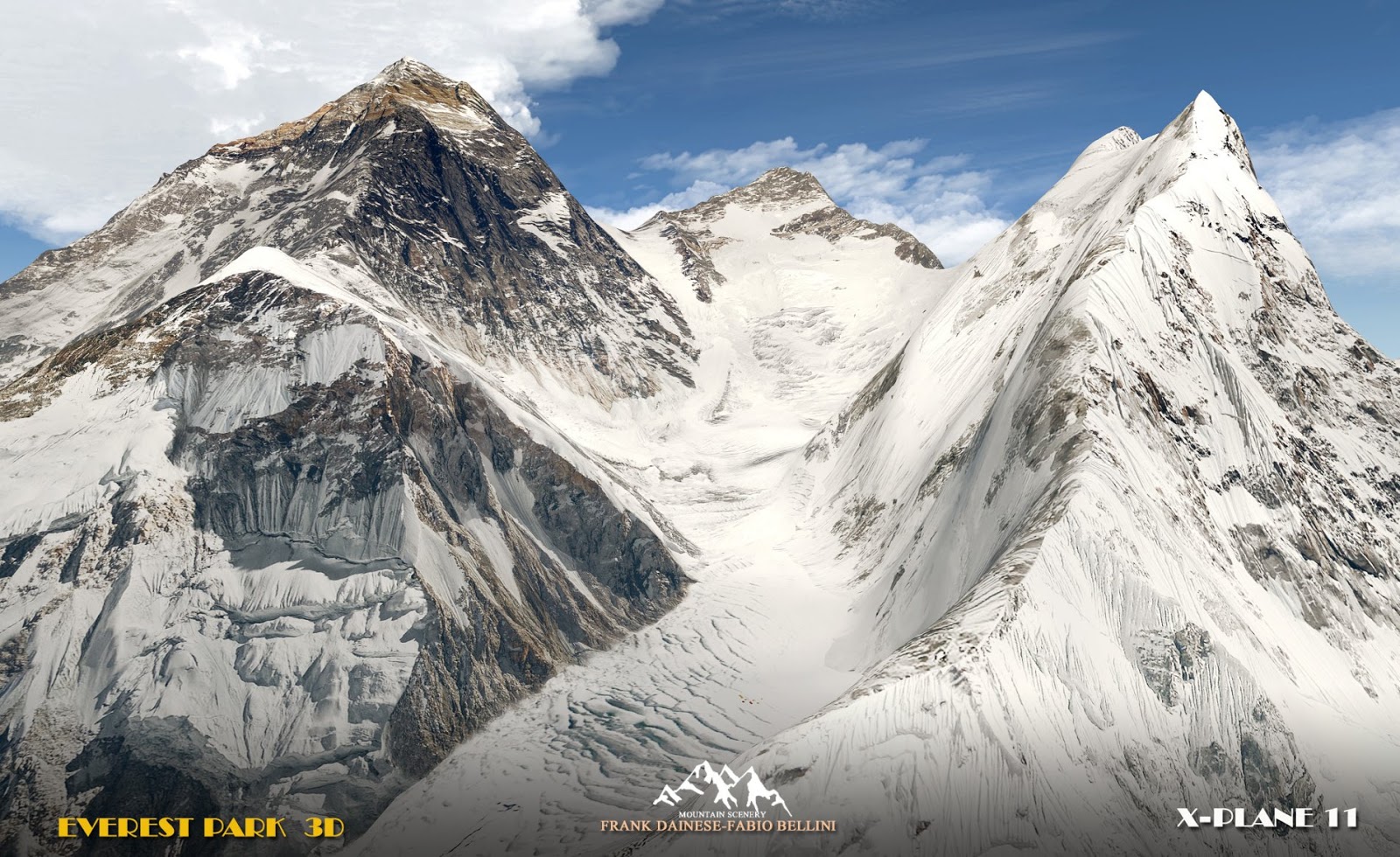
Sua Maestà l'EVEREST !
Ecco finalmente il protagonista dello scenario : l'EVEREST che con i suoi 8848 mt. (29029 ft) è il tetto del nostro pianeta!
Ho usato texture con risoluzione 4k ricavate da foto in HD, soprattutto per i due versanti più frequentati (alpinistici) : Sud Sud-Ovest (Nepalese) e Nord Nord-Ovest (Cinese/Tibetano).
Il modello 3D posizonato sulle mesh, con grande maestria da Fabio, ha esattamente l'atezza di 8848 mt.
Anche per tutti gli altri modelli 3D è stata rispettata la loro altitudine.
Ecco le prime foto ufficiali dell'Everest che rappresentano il vero obbiettivo dello scenario. E' stato scelto il periodo pre-monsonico, quindi prima delle grandi piogge/nevicate, dove lo stesso Everest in certe foto è quasi senza neve. Il motivo è legato ai forti venti che alle grandi quote spazzano via i "granelli di ghiaccio/neve" facendo apparire le rocce sottostanti. Famosa la grande fascia gialla subito sotto alla piramide sommitale, molto ben visibile anche da grandi distanze, una caratteristica comune anche ad altre montagne ma che per l'Everest rappresenta un "segno" di riconoscimento.
Consiglio di ingrandire le immagini per vedere meglio i dettagli:


A breve cominceremo i test...
Subscribe to:
Posts (Atom)