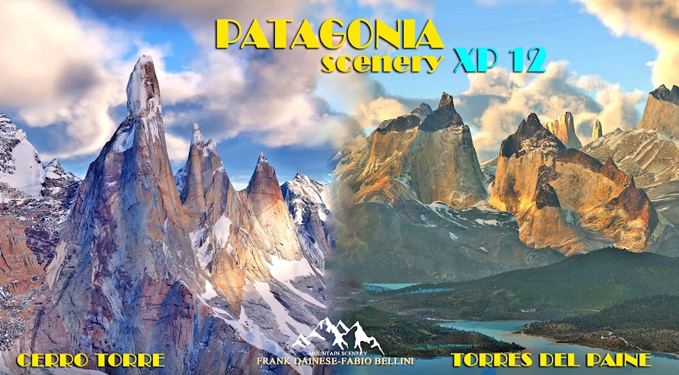
4 anni fa ho ricostruito per FSX/P3D la zona del Cerro Torre-Fitz Roy- El Chalten. Era uno scenario free ,ora non più disponibile.
Qualcuno mi ha chiesto "come mai quello per X-plane sarà a pagamento?". ...le differenze di qualità e il lavoro necessario per lo sviluppo in x-plane è nettamente superiore. le Textures saranno tutte migliorate e tutto il paese di El Chalten completamente ricostruito in 3D.
qualche immagine di comparazione.
Work in progress... ... and also during the Christmas holidays Fabio is working on the meshes. adaptation is always complicated, the perfect positioning of 3D models involves many steps and numerous attempts. The preview pictures that I have inserted on Blog, are just an example and positioned in but without any obligation of precision.
4 years ago I rebuilt the area of Cerro Torre-Fitz Roy-El Chalten for FSX / P3D. It was a free scenery, now no longer available.
Someone asked me "why the one for X-plane will be pay?". ... the differences in quality and the work necessary for development in x-plane is much more. the Textures will all be improved and the whole country of El Chalten completely rebuilt in 3D.
some comparison image.


Qualche spiegazione e chiarimenti ad alcuni interventi su vari forum:
è stato scritto da qualcuno (molto raro) che i nostri scenari non sono corrispondenti alla realtà.
risposta: mai pretesa la perfezione, ma solo vero somiglianza. Non esistono scenari perfetti..Sviluppare scenari di montagna è molto più complicato rispetto ai semplici scenari su zone di pianura. ....e comunque i nostri modelli 3D delle montagne sono sicuramente più verosimili, rispetto alle montagne riprodotte dalle mesh+ortofoto. Le ortofoto sulle pareti verticali sono nulle, creando un effetto slavato e sfocato.
L'uso di ortofoto per scenari è molto costoso e improponibile per sviluppatori "artigianali", in molti casi sono anche di scarsa qualità o coperte di nuvole. Io uso un metodo studiato e perfezionato per riprodurre il terreno della zona interessata, basandomi su semplici fotografie. In molte situazioni di zone montuose questo è più semplice perchè il terreno normalmente è ricoperto da vegetazione boschiva. In pratica considero le ortofoto non obbligatoriamente necessarie:
1) le montagne le costruisco con modelli 3D
2) la vegetazione in 3D mappata e riprodotta
3) le zone abitate, tutte ricostruite in 3D
4) Altri particolari come strade, fiumi, laghi... tutti riprodotti
Le ortofoto potrebbero solo ricoprire i prati e le zone libere da vegetazione... molto facilmente riproducibili con semplici poligoni/textures.
Questi sono i motivi della nostra scelta di non usare le ortofoto in zone di montagna.
Poi l'aggiunta di particolari come piccoli aeroporti, eliporti (dove non esistono), hanno il solo scopo di aumentare il divertimento della simulazione. Infatti l'obiettivo principale è divertire..
Some explanations and clarifications to some interventions on various forums:
It has been written by someone (rare) that our scenery don't correspond to reality.
answer: never claimed perfection, but only true-resemblance. There are no perfect scenery. Developing mountain scenery is much more complicated than simple scenery on lowland areas. .... and anyway our 3D models of the mountains are certainly more likely, compared to the mountains reproduced by the mesh + orthophotos. The orthophotos on the vertical walls are void, creating a faded and blurred effect.
The use of orthophotos for scenery is very expensive and not feasible for "craft" developers, in many cases they are also poor quality or covered with clouds. I use a method studied and perfected to reproduce the terrain of the affected area, based on simple photographs. In many situations of mountainous areas this is simpler because the ground is normally covered with forest vegetation. In practice, I consider orthophotos unnecessary:
1) I build the mountains with 3D models
2) the 3D vegetation mapped and reproduced
3) the inhabited areas, all reconstructed in 3D
4) Other details such as roads, rivers, lakes ... all reproduced
The orthophotos could only cover the lawns and the areas free of vegetation ... very easily reproducible with simple polygons / textures.
These are reasons for our decision not to use orthophotos in mountain areas, in addition to the cost.
Also the addition of details like small airports, heliports (where they do not exist), have the purpose of increasing the fun of the simulation. In fact, the main goal is to have fun...


